Good Thursday! One more dry and fairly hot day ahead, then we'll be dealing with Isaac. The front edge of Isaac's cloud cover is moving into the area from the south this morning. Local 6 viewer Gary Hargrove shared a dramatic shot of those clouds arriving against the backdrop of some morning sunshine:
Since yesterday, we haven't seen much change to the forecast track of the remnants of Isaac over the next few days...still looks like it heads through Arkansas and into central MO, then takes a sharp turn to the east and crosses central IL & IN:
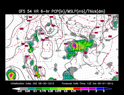
One last time with this system, here's a rundown of what the models are showing. Remember, the colored portion of these charts represent 6-hr precip accumulation.
GFS at 7PM Friday:
7AM Saturday:
7PM Saturday:
7AM Sunday:
7PM Sunday:
Now the European model...starting at 7PM Friday:
7AM Saturday:
7PM Saturday:
7AM Sunday:
7PM Sunday:
Feel pretty confident that the most widespread showers and storms will remain to our southwest through Friday morning. That is when our chances will start to increase. Lots of moisture will be surging in, allowing for widely scattered showers and storms to increase across our area for Friday afternoon and evening. Not looking for continuous rain Friday night, but certainly periods of storms, some with heavy rain, and some gusty winds up to 30 mph....possible higher if an isolated severe storm or two can develop. With any tropical system, there is a decent amount of wind shear, so while the threat of severe weather is low, there is a chance of isolated severe weather where some pockets of heating and instability develop....and an isolated weak tornado can't be ruled out. Saturday will likely be the wettest day of the weekend, with Sunday seeing chances diminish slightly as the system continues to weaken and move away.
Rainfall totals continue to be highly dependent upon the exact track of the center of the low and where some training of showers and thunderstorms occur. Here's a couple of looks at different forecast models and agencies' forecasts.
Latest HPC forecast (KY: 1.5"-3.0"....IL: 2.5"-4"....MO: 1.5"-4"...TN: 1-2"):
Latest GFS forecast (KY: 1-2"...IL: 2-2.5"...MO: 1.5-2.5"...TN: 0.5-1.5"):
Of the two above, the HPC trend is worth noting, but I believe it may be a bit too much. Meanwhile, the GFS looks more reasonable. I think a good middle of the road is the European model that I showed this morning on Local 6 Today:
Will be interesting to see how this all plays out. It's sure been a challenging forecast!
Finally, we need to look ahead to next week, including the Labor Day holiday. After we say goodbye to Isaac, there will be a lot of tropical moisture left behind. As skies clear, this means very warm and humid conditions for the first half of the week. There is a chance of scattered storms on Monday, especially during the afternoon hours...but certainly not a washout. Outdoor plans for Monday are okay for now, but keep an eye out for those scattered storms.


No comments:
Post a Comment