Quick update to the original post....the struggling T.D. Five I wrote about earlier apparently wasn't struggling as bad as we thought, and was named T.S. Ernesto this afternoon. The 5-day forecast shows the potential for this storm to head toward the Gulf of Mexico as a hurricane by the first of next week...certainly worth watching.
The Thursday entry is highlighted by the chance for some rain and storms today and tonight. The rain would be great, but with temperatures hitting 100 degrees for the 17th time this summer, the atmosphere is quite unstable, setting the stage for a few of the storms that develop today to reach severe limits. Damaging winds are the primary concern with storms today. All of the Local 6 area is included in the SPC's slight risk area.
With an unsettled regime over the region for a few days, we'll have periodic chances for scattered showers and storms through the weekend, but it appears right now that the highest chances will be tonight and again Saturday night/Sunday. Here's a few images of what the forecast models are showing us:
HRRR model at 8PM tonight:
European model ending at 7AM Friday:
NAM model ending at 7AM Friday:
GFS model ending at 7AM Friday:
That's some pretty good model agreement....so I think it's probably a good idea to plan on some showers and thunderstorms moving through tonight! As for totals...0.25-1.00" is probably a fair estimate. Of course with the scattered nature of these storms, there will be localized higher/lower totals.
Friday PM-Saturday we'll probably keep rain chances in the 30% range, with no real trigger for organized activity. Another wave of energy arrives Saturday night/Sunday, so we'll see higher chances around 40%. Here's a couple more forecast model images:
European model 1PM Sunday:
GFS Sunday 7AM:
Timing doesn't match up exactly, but there's at least hope for another round of wet weather there. We'll be fine-tuning that forecast over the next couple days.
--------------
Drought Update:
The new U.S. Drought Monitor was issued this morning. Not much change across our region...the vast majority of the Local 6 region is still in D4 exceptional drought. You can check out all the info by clicking here.
The numbers are staggering when you look at the larger scale. If you average the numbers for July for the lower 48 states, the 2012 drought is second only to the Dust Bowl drought of 1934 in terms of area. Here's how it ranks:
1) July 1934 - 80%
2) July 2012 - 62%
3) Dec 1939 - 60%
4) July 1954 - 60%
5) Dec 1956 - 58%
Another note...yesterday the USDA moved to declare that 50.3% of the counties in the U.S. are natural disaster areas due to the drought.
------------------
Tropical Update:
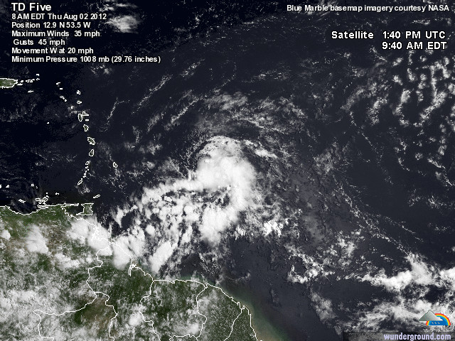
The tropical wave I've been following the past few days was named T.D. Five yesterday. Here's a satellite image from this morning:
It is currently encountering some significant wind shear and drier air, which is keeping this system rather weak and disorganized. The next two days or so will determine whether this storm will continue on or be ripped apart. If it is able to hold on into the weekend, that may open the door for this system to take a turn toward the Gulf of Mexico. Here's the latest model tracks:
Finally, here's a check of your 7-Day Planning Forecast:


No comments:
Post a Comment