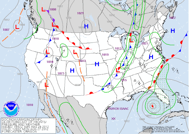
When we wake up on our Monday morning, a cold front will be knocking on our door to the west, leading to a chance of scattered showers & thunderstorms through the day. Here's the surface map at 7AM Monday:
I believe the highest chances will be across the KY & TN during the PM hours when the atmosphere is at it's juiciest....but once again, things will be widely scattered, and rainfall totals will not be too impressive. HPC indicating perhaps up to 0.25":
That cold front will be east of the area by Tuesday, leading to the return of sunshine for mid week. Temperatures will remain pretty hot, with highs in the lower 90's. Dry weather will stick around through Thursday....which brings us to Friday, and potential impacts from Isaac. Before we talk locally about Isaac, let's go in depth on the latest with this storm.
Here is the latest advisory from the National Hurricane Center as of 8PM EDT tonight:
Isaac continues to be a strong tropical storm with maximum sustained winds of 65 mph. It has not been able to make the jump to a hurricane yet because of its close proximity to land (Hispaniola, Cuba, & South Florida), and because of dry air being drawn into the storm. However, since the 5PM EDT update, winds have increased, and the pressure has dropped, showing us that the storm is getting stronger. And as the track above indicates, the storm will be spending the next two days over the open waters of the Gulf of Mexico, where sea surface temperatures will work to strengthen the storm. Wind shear is low as well, another factor favorable for strengthening. Most likely we'll see this become a hurricane later on Monday evening or Tuesday morning. Intensity forecasting is one of the most challenging aspects of tropical weather, so this forecast very well could change.
The biggest development with Isaac over the past couple of days has been the westward shift in the projected storm track. As if forecasting intensity wasn't difficult enough, forecast models have been making the path of Isaac a real headache. Check out these two models:
Here's the 12Z GFS model, showing landfall in LA:
Meanwhile, the 12Z European model has landfall some 300 miles east on the FL panhandle:
That is a very large difference (about 300 miles), considering this storm is only about 48-60 hours from impact. But, just after looking at those two models, I ran across another group of model data that seems to be indicating that the more westward solution may be the one to look toward, and data that makes me think the NHC forecast cone will continue to trend westward toward Louisiana:
With all of the that info in mind, the NHC has posted hurricane and tropical storm warnings along the Gulf coast:
The hurricane warning stretches from near Morgan City, LA, eastward to Destin, FL. This means that hurricane force winds of at least 74 mph are expected in these areas with the next 24 hours. They also estimate that IF peak storm surge arrives at the same time as high tide, water levels could rise some 6-12 feet within the hurricane warning area. Total rainfall amounts of 5-10 inches, with localized amounts up to 15 inches will likely accompany the storm.
Now, coming back home, the big question on everyone's mind is how Isaac will affect us locally. If you check the official NHC 5-day cone, then bring the remnant low/tropical depression to near Memphis by Friday afternoon. That's a good sign for us! The GFS & European are also showing some wet weather for us:
European model at 7PM Friday:
GFS model at 1AM Sunday (probably a little too slow):
So, bottom line, what was a big IF last week is looking more likely. That said, with forecast models still differing a bit, I'm not totally ready to fully commit to putting a soaking tropical rain in our forecast just yet. But I am getting more optimistic. One more thing...when many of us hear something about the remnants of a hurricane, it probably stirs up memories of the remnants of Ike in September 2008, when we were pounded with 70-80 mph winds and massive power outages. I can say with very high confidence that a similar situation is very unlikely with the remnants of Isaac. Ike was a much more powerful hurricane when it made landfall, which then interacted with a strong jet stream and cold front, creating sort of a "perfect storm" situation. Those conditions will not be available for this storm. By the time Isaac reaches us, the winds will be pretty much gone....just leaving behind some rain...we hope! Stay tuned for additional updates over the next few days!


No comments:
Post a Comment