Saturday, November 26, 2011

A Messy Forecast

Late update here on a Saturday night.  There's been some big changes since yesterday's blog post, so I wanted to fill you in.  As expected, the rain has arrived tonight, and it looks like we're in for a soaking.  Through Sunday night, much of the region is expected to rack up 1-2" of additional rainfall.  Here's the latest rainfall forecast graphic (6PM Sat-6PM Sun):


Along with this rain, a strong cold front will move through by Sunday morning, causing winds to shift to the NNW and temperatures to drop as the day wears on.  We'll drop to the mid 40's overnight, then fall to near 40 by Sunday at dusk.

The big change since yesterday is that the "closed-low scenario" that forecast models had gone back and forth on appears to be happening after all, which will have a major impact on our Monday & Tuesday weather.  Instead of getting back to dry weather, things will stay cold and wet until Wednesday.  Before I go into more details on the forecast, let's looks at what I mean by a "closed low".

At some point you've probably heard us discuss troughs and ridges....ridges are associated with high pressure, troughs with low pressure.  Usually cold fronts and unsettled weather accompany a trough, which is certainly the case this weekend.  Here's a look at a forecast model showing a large trough across the central U.S. as of Sunday AM:


See the big dip with the bright colors that looks like a "V"....that's the trough, sometimes called an "open wave".  As this trough deepens and evolves, it will develop into a closed low by Monday morning. Here's what that looks like on the models:


Notice how the white lines have closed off?  There's your closed low.  These are also sometimes called "cold core lows".  The ultimate result of this low is that it will keep moisture flowing in from the east, and at least on the western side of the low, will pull in colder air from the north.  This means rain chances will continue into Monday and Tuesday.  It also means that some of us may see our first snowflakes of the year.  Let's check out another model chart...


I know they are a little tough to see, but look at the dotted red and blue lines on this chart.  Those are atmospheric thickness lines.  Without getting too technical, they basically give an indication of temperatures, and where you see the blue lines, that is sort of a "quick glance" check of where it is cold enough for frozen precip to form....something we call the "540 line".  Sure enough, right in the very same region as our closed low, we find the 540 line, and a chance for rain to mix with or change over to snow.  Based on the forecast position of the low, it looks like the coldest air will be found over southeast MO & northwest TN, and thus the best chance for some flakes Sunday night and Monday.  There may also be a little mixing or a changeover again Monday night and Tuesday morning.

As far as the snow portion of the forecast, this is really only a big deal simply because it's the first chance of snow this season.  With warm ground temperatures, there's no reason to think anything will stick, and any snow that does fall won't amount to much anyway.  So no reason to go buy bread and milk...unless you just need some!  The rainfall portion of the forecast is a different story.  By the time this system moves out Tuesday night, many of us will have added another 2-4" to rain gauges that have already measured a lot of rain this month.  Before the beginning of tonight's rain, we had 9.25" here at the station this month, and the NWS Paducah had 7.48".

Friday, November 25, 2011

Rain This Weekend...And More???

Hello everyone!  I hope you had a wonderful Thanksgiving, and got some good deals if you were one of those dedicated Black Friday shoppers.  Cheesy as it sounds, I've been advertising today's weather as a "one-day only deal", with big discounts on cloud cover leading to lots of sunshine, and mild temperatures in the lower 60's as a free gift! 

Unfortunately, the pleasant weather ends tomorrow, as a strong cold front will be sweeping across the central U.S., bringing widespread rain, winds, and colder temperatures.  Here's what our weather map will look like by tomorrow at 6PM:

A cold front will be in the process of moving through the region, bringing widespread rain to the Local 6 region.  Rain could arrive as early as sunrise in southeast MO, but the highest rain chances will run from around midday through the evening.  This will be another steady, soaking rain once it sets in, with pretty hefty totals expected, especially the farther east you go.

Rainfall totals through 6AM Monday (seen above) should reach near an inch across southern IL & southeast MO, and should range from 1-2" across western KY & northwest TN.  Even heavier amounts are expected from central KY into middle TN and northern MS & AL, where 3 or 4 inches will be possible.  This will certainly dampen the drive home across much of the mid-south over the holiday weekend, and may end up causing several delays at airports across the eastern U.S.

As this front continues to press east Saturday night and Sunday, colder air will quickly fill in....and if the cold air can catch up to the moisture quick enough, a few spots across the eastern U.S. could see a few snowflakes.  The next two graphics show where snow may fall....however, I'm going to include a disclaimer that based on some of the model data I looked at, I think these forecasts are a bit overdone. 


The graphic above shows the probability of at least 1" of snow through 6AM Sunday.  Notice parts of southern IL & west KY are being shown in the 40-80% range.  Again, I think this is too high.  With this system moving east pretty quickly, I think most of the deep moisture is out of here before the cold air can arrive.  We may have a couple of sprinkles or flurries Sunday, but I believe most of the day will be dry. Moving on, here's the same graphic for the next day:
This graphic for the probability of at least 1" of snow runs from 6AM Sun-6AM Mon.  I do think it is more possible to see some flakes flying farther to our east, but shouldn't amount to much.

So, bottom line....rain is almost a certainty for Saturday, but should end by Sunday morning, with only a very slim chance of a few flurries mixing in on the tail end of this system.

Beyond this weekend, the majority of forecast models continue to be in agreement that this system will clear out by Monday & Tuesday, giving us mainly clear skies.  However, there is at least one model still indicating a slower departure to this system, so I'm not ready to fully commit to sunshine for Mon/Tue...we'll go with partly cloudy for now.  Temperatures next week will be turning colder, with daytime highs from Sunday-Thursday not likely to get above 50.  Overnight lows through that same period will run in the neighborhood of 30. 

A quick scan of the extended 8-16 day charts shows a pretty uneventful beginning to December, with little to no precipitation showing up, and temperatures running pretty close to seasonal norms.

Thursday, November 10, 2011

11/11/11...A Historic Storm

Greetings!  Tomorrow is a special day on the calendar....it's 11-11-11, the perfect palindrome!  This is coming on the heels of another numerically special date a little over a week ago, which was 11-02-2011, another palindrome.  Aside from being a once-in-a-century day on the calendar, there is also some interesting weather history that occurred 100 years ago, on 11-11-1911. 

One of the most dramatic drops in temperature ever recorded occurred during the late afternoon and evening hours in what is known as The Great Blue Norther of 1911.  A fast-moving and very powerful cold front was sweeping south from the Northern Plains with no warning.  Many midwestern towns enjoyed blue skies and set record highs during the afternoon, with residents leaving their coats and jacket behind to enjoy a final taste of summer-like weather.  Afternoon temperatures across Missouri rose to 76 in Kansas City, 78 in St. Louis, 80 in Springfield, and 82 in Columbia. 

However, as late afternoon arrived, those blue skies began to look violent....

As the clouds rolled in, winds quickly became violent, with hurricane-force winds accompanying the cold front.  Some locations reported violent thunderstorms, and even tornadoes with this system.  In fact, farther north, a tornado tore through much of the town of Owosso, MI, and according to records, struck around 11PM on 11-11-11.  It is now referred to as the "Tornado of the Elevens".
Owosso, MI...notice the caption on the photo that reads "11 P.M. 11-11-11"

In just a matter of an hour or two after the arrival of this front, temperatures dropped some 40 to 60 degrees, and rain and hail turned to sleet and snow.  The automatic temperature trace from Springfield, MO, shows a drop of nearly 60 degrees in 2 hours.
Springfield, MO temperature trace:  Record high of 81 just before 4PM, dropping to 24 at 6PM, and a record low of 10 at midnight.

For more reading on this historic weather system, here are a few links from other sources:
University of Missouri:  http://cafnrnews.com/2011/10/midwests-perfect-storm/

NWS Springfield:  http://test.crh.noaa.gov/sgf/?n=event_1911nov11_user1

NWS St. Louis:  http://www.crh.noaa.gov/lsx/?n=11/11/1911coldsnap

Thursday, November 3, 2011

A Look Ahead....Stormy, Then Colder?

Greetings!  As expected, our Thursday got off to a wet start, with around 0.55" of rain here at the weather center.  It was an upside-down almanac day too....with our high temperature for the day of 60 degrees coming at 3AM, and a 45 degree reading as of this update at 4PM serving as our low for the day.  The upper-level low responsible for today's gray skies will shift off to the east tonight and tomorrow, bringing a return to sunshine to the area by our Friday afternoon.  In the wake of this upper-low, a nice ridge will build in for the weekend, allowing temperatures to moderate back into the upper 60's for daytime highs, with plenty of sunshine. 

7AM Sat.-Large ridge over Mid MS Valley, developing trough over the Rockies

By the first part of next week, we'll enter into a more unsettled pattern just in time for Election Day, as a storm system that will develop over the weekend across the Rockies begins to push eastward.  This will set us up for the potential for some stormy weather on Tuesday and Wednesday.

7AM Tuesday-Strong trough over the central Plains, putting our region in strong SW flow, leading to warm, moist air setting the stage for showers and thunderstorms.

This system will approach the region Tuesday, and bring a surface low and attendant cold front through the region Wednesday, leading to showers and perhaps some thunderstorms.  The Storm Prediction Center is including parts of southern Missouri and Arkansas in a risk for severe weather, so we'll want to keep an eye on the development of this system to see if parts of the Local 6 region may have to deal with strong storms as well.

 Storm Prediction Center's 4-8 Day Severe Weather Outlook

Behind this system, temperatures again look like they will fall into the 50's for highs and 30's for lows by the end of next week.  But, it's what might be on the way about two weeks from now that really caught my attention earlier today when looking through some longer-range forecast models.  A blast of cold air coming down from Canada may finally bring the first freeze to the region, with temperatures in the upper 20's being advertised by the morning of Thu. Nov. 17.

7AM, Thu., Nov. 17-GFS Surface temperature map showing readings in the upper 20's across the Local 6 region.

One thing to note, in my last blog I included some info on first freeze dates, and if freezing temperatures do not arrive until the 17th, it would set the record for the latest first freeze....with the previous latest date coming on Nov. 13, 1975.  We'll see what happens on the specifics, but one thing is for sure, cold air is coming, like it or not!

Thursday, October 27, 2011

Thoughts on winter 2011-2012...

Greetings....it's been way too long since my last post here!  I hope to be more regular with updates here as we head into the typically active periods during the late fall and winter months.

While temperatures are getting chilly on us, we really seem to have had a fairly warm autumn thus far, and a review of the climate data shows that we are actually now behind schedule for our first freezing temperatures of the season.  Based on the most recent 30-year averages (1980-2010), the average date for the first freeze in Paducah is October 25.  The earliest freeze on record was Oct. 3, 1974, and the latest date for first freeze was just a year later on Nov. 13, 1975.  Looking at some of the long-range forecast model numbers, unless something changes, that record for the latest freeze could be in jeopardy this year!  The 16-day GFS model currently takes us all the way out to Nov. 12, and shows the coldest temperature at around 37 degrees by next Friday morning.  Now, as I've mentioned before, it's a stretch to consider anything that far out as a certainty, but the general trend in the models supports this idea of somewhat milder weather continuing.

Looking a bit farther out into the distance, the Climate Prediction Center has released the November outlook, which shows our region having a 33% chance of above average temperatures for the month, as well as a 40% chance of below average precipitation.  You can view the CPC's monthly outlook by clicking here.

Finally, I'll grab the binoculars and look way out over the next few months of the upcoming winter.  The chatter around town already has people talking about rumors of another rough winter or another big ice storm.  I think after experiencing the catastrophic ice storm in 2009, there are probably going to be rumors like these just about every winter.  Granted, most of us are pretty spooked by winter weather, and the dangers it can bring.  And yes, it is true that we have been the victim of more than our fair share of extreme weather over the past few years.  But, the only thing these rumors do is get people riled up and worried.  The fact of the matter is that any sort of long-range outlook can only look at general climate trends, and simply cannot accurately predict any specific weather event such as an ice storm, snow event, or severe weather outbreak more than a week or so in advance.  Any forecaster that says otherwise is just trying to stir something up.  Instead of buying into rumors and worrying about what may happen, your best bet is to simply be prepared for whatever winter may bring.  Okay, rant over.....

On to some actual scientific talk about the winter ahead...last year's winter was heavily influenced by two large-scale climate patterns.....La Nina and the Arctic Oscillation.  La Nina, a cooling of the waters of the central and eastern Pacific Ocean, typically leads to warmer-than-average conditions across the southern U.S., and typically leads to wetter-than-average weather for our part of the country.  La Nina certainly contributed to last spring's historic flooding on the Ohio & Mississippi Rivers.  While this year's La Nina isn't forecast to be as strong, it still should lead to quite a bit of precipitation and perhaps increased storminess for our region.  The "wild card" in looking at the winter outlook is the Arctic Oscillation.  This feature is much less predictable, and more erratic.  It can quickly fluctuate from it's positive phase to the negative phase, which aggressively drives cold air from Canada south into the U.S, leading to cold air outbreaks and winter storms.  These negative phases can last anywhere from a couple of weeks to a month long, and really can't be predicted more than a week or so in advance.  It's this feature that really makes any sort of specific winter weather predictions nearly impossible.  All of that to say that the official winter outlook from NOAA shows our area as having equal chances of average, below average, or above average temperatures this winter, and a 33% chance of having about average precipitation.  We'll have to wait and see how that all plays out!  For the full article released by NOAA on their winter outlook, click here.

Wednesday, September 14, 2011

Another Taste of Autumn

A nice batch of showers and thunderstorms are rolling across the area as I type this update...much needed rain as parts of western KY & northwest TN are in moderate drought conditions.


The cold front and associated area of low pressure responsible for bringing today's showers and storms will press on to the east tonight, and most of the precipitation should be out of the area shortly after midnight.

The big story with this system will be the drastically cooler air that pushes in as a big dome of Canadian high pressure takes over in the wake of the front. 
You'll notice a big difference in temperatures as early as tomorrow morning, when lows could drop into the upper 40's across portions of southern IL & southeast MO, if skies can clear out quickly.  Tomorrow afternoon, temperatures will struggle to reach 70 with a blustery north wind expected.  Then tomorrow night, it's not out of the question that a few spots could flirt with record lows, as temperatures fall into the mid 40's.  The record for Thursday night/Friday morning at Paducah is 44 degrees.

By Sunday, the center of high pressure will drift east into New England...
With the return flow, winds from the south will pump some warmer air back into the region for the end of the weekend and first of next week.  This will also bring moisture back into the region, possibly setting us up for some scattered showers and thunderstorms by the first of the week.  More on that in the next few days.

Saturday, September 10, 2011

La Nina Returns

While our overall weather pattern will remain fairly quiet for the immediate future, a look way ahead to the upcoming few months reveals that things may grow to become pretty active again over the winter and spring months, thanks in part to the return of La Nina.  La Nina...the "female" counterpart to El Nino, is an overall cooling of the waters of the central and eastern Pacific Ocean.  A recent look at sea-surface temperatures in the Pacific show that this climatic setup has returned.

Of course, there are a number of other atmospheric factors that will ultimately determine how our weather unfolds over the winter and spring months, but usually this type of setup brings wetter than average conditions to the Ohio Valley.  La Nina was certainly a contributing factor during last winter's record snowfall across parts of the central U.S., the record flooding across our region last spring, as well as the record number of tornadoes in April.  This will be a story worth following over the coming months, and could lead to more volatile weather during the more active months to come.  The official NWS winter outlook will arrive in mid-October, so it will be interesting to see how this plays into their predictions.  To read more about the latest La Nina information, check out this link:

http://www.noaanews.noaa.gov/stories2011/20110908_lanina.html

Sunday, September 4, 2011

Windy Labor Day & Problems From Lee?

Hey there...hope you are enjoying your Labor Day weekend!  What a big change over the past 24 hours!  After nearly reaching 100 degrees yesterday, we held steady in the 70's today, with plenty of clouds and scattered showers associated with moisture from Lee and the cold front that moved across the area.  Tonight, a look at the surface map shows the front pretty much through the entire region, and the cooler, drier air moving in from the north.

With high pressure behind the front, and lower pressure at the center of Lee, our region will be stuck in a pretty big pressure gradient tomorrow, leading to a breezy Labor Day.  A Lake Wind Advisory is in effect for Monday, with NNE winds of 10-20 mph, gusting as high as 30-35 mph, with the strongest gusts the farther south you go.  And a big question mark for tomorrow will be how quickly we clear out. With moisture streaming north from Lee, it may take most of the day for clouds to clear out east of the Mississippi River.

Looking ahead, since the last post there have been some changes in the forecast models' idea of how the remnants of Lee will impact our weather picture this week.  It's a rather complicated situation with multiple variables, so some tweaking may occur to the forecast over the next few days.  As Lee begins to wind down and become post-tropical, it will be phased into the existing cold front that is moving through our area, and will move northeast along that front.

At the same time, Hurricane Katia is still slowly churning northeast across the Atlantic, headed in the direction of the east coast.  As you can see below, it still appears that Katia will not make landfall, but will get a little too close for comfort.


Ultimately, by mid-week it looks like the remnants of Lee will develop into what we call a cut-off low...an area of low pressure that is not connected, or "cut off", from the steering currents of the jet stream.  These features typically hang around for a few days, and lead to cloudy, cool, and sometimes rainy weather.  And with Katia approaching from the east, this system will effectively block other features, such as this low, from moving east, at least until Katia exits the picture. Here's what that looks like on the model chart by Wednesday morning:
Notice the "L" surrounded by circles over MS & AL?  That's our cut-off low.  Here's the surface chart for the same time period:
Notice the purple over the Local 6 area?  That indicates light rainfall over our region.  All of this is has been hinted at by one or two of the models for a few days, but today just about all of the models came into agreement on this scenario, which led to some big changes to the forecast for this week.  I went ahead and kept things mostly cloudy for Wed.-Sat., with daily 30-40% chances for rain, and slightly cooler temperatures.  We'll see how this whole thing plays out.....if Katia's track diverges, then the forecast will have to be adjusted as well.  Stay tuned.

Wednesday, August 31, 2011

A Hot Start to September....Cooler Labor Day

After a pleasant start to the week, we're back to some intense heat for the second half of this week.  Here is a look at some of our area's temperatures as of 4PM today:
And so the dog days of summer continue...with more heat on the way for the rest of the week. Below are shots of the surface temperature forecasts for 3PM according to the NAM forecast model...both showing upper 90's for our region, with maybe even a pocket or two of 100's in SEMO:

Thursday:
 Friday:
There is a little bit of good news, however, with these temperature forecasts.  With very little rain over the past few weeks, so much moisture has been sapped from the ground that the humidity levels will not be all that oppressive. 

As we look to the weekend, some drastic changes are on the way for area thermometers.  A pretty strong cold front looks like it will make it through the region sometime on Sunday, and that will spell big relief from this current heat.  Here's a look at the HPC map, showing the front already much of the way through the region by 7AM Sunday:
The unfortunate aspect of this frontal passage is that unless something changes, there isn't going to be much moisture to work with, and while we may have a scattered shower or two Saturday night or Sunday, we're not going to see much rain with this system....really our only chance for rain in the near future.  While a rain-free forecast is good for those Labor Day plans, we'll end up nearly 1.5" below average for the month of August. 

After the front moves through, we're in store for a refreshing change in temperatures, as numbers should end up in the upper 70's to around 80 on Monday.  And earlier today I took a glance over the 16 day GFS forecast for temperatures....Saturday could be our last 90 degree day for quite some time.

Moving from home to the tropics...still watching Katia today, as she is close to becoming a hurricane.  The 5-day forecast still continues to show this storm becoming a major hurricane over this weekend:
However, the news continues to be good for now, as the GFS ensemble models continue to show this storm curving northward before it has the chance to impact the eastern U.S.  Still way too early to make predictions with any certainty, but this storm doesn't appear that it will pose the same threat as Irene.
There is another area of disturbed tropical weather worth watching....this one is a disorganized batch of clouds and thunderstorms out in the Gulf of Mexico.  This may end up being a nice rain maker for the Gulf Coast, but the NHC is only giving it a 30% chance of becoming a named storm over the next 48 hours.

Sunday, August 28, 2011

The Week Ahead & More Atlantic Action?

As we expected, temperatures and humidity levels were down slightly for our Sunday after the passage of a weak cold front last night.  We'll get to squeeze in a couple more days with lower humidity and highs in the mid/upper 80's on Monday & Tuesday, with lows in the upper 50's to around 60.
By Wednesday, a warm front will make its way northward through the area, which will bring just a very small chance of an isolated shower or storm, and will also bring the return of the 90's and higher humidity, just in time for the beginning of September. 


Looking ahead to Labor Day Weekend, a cold front will be trying to slide in from the northwest, this will bring a chance of showers and thunderstorms to the region.  At this point in time, this looks like the best chance of rain for the next week, which isn't saying too much, considering moisture will be limited with this system.  This should bring at least a small cool down by the Labor Day holiday.

Now onto the Atlantic...just as Irene winds down, Tropical Storm Jose has joined the club.  This storm may bring some rain and wind to Bermuda, but doesn't look like it should be much of a troublemaker.

The bigger concern is a tropical wave way out in the eastern Atlantic, south of the Cape Verde Islands....currently known as "Invest 92", indicating that the National Hurricane Center is closely monitoring the system.

 As of the 8PM update tonight, the NHC was forecasting a near 100% chance of this becoming Tropical Storm Katia over the next 48 hours, and the GFS ensemble forecast models paint and interesting picture with the forecast for the possible track of this system.

As you can see by the image above....this system could be headed into the same general areas that just dealt with Irene.  Of course this system is still way too far away to even think about making any sort of specific forecast, but this certainly is attention-grabbing, and will be interesting to monitor this week.

Friday, August 26, 2011

Good Looking Weekend Here...& Irene's Impact

A very quiet weather pattern for the Local 6 area continues....I'll let the weather story graphic from the NWS Paducah do the talking.


Now...onto Hurricane Irene. Hurricane Warnings are now in effect from North Carolina all the way north into Massachusetts.  The storm has weakened a bit over the past 24 hours, now down to a CAT 2 hurricane, with max winds at 100 mph.  However, this is a huge hurricane, with hurricane force winds extending outward to 90 miles from the center, and tropical storm force winds out to a whopping 290 miles from the center.
This huge wind field means that some areas will be impacted by tropical storm force winds (39-73 mph) for anywhere from 15-22 hours!  This also allows for the water to pile up under the center of the storm, making for a large storm surge. The latest info shows storm surge potential of 6-11 feet for coastal portions of NC, and 4-8 feet from Chesapeake Bay north through Cape Cod.
And on top of all the water being pushed inland from the ocean, rainfall totals will be tremendous.  Anywhere from 6-12 inches of rain are expected with the worst of the storm, with localized totals of up to 15 inches possible.

Even though this storm has weakened a bit, it is still going to prove to be a destructive and historic hurricane for the Mid-Atlantic and Northeast.  With over 65 million people in the path of the storm, the economic impact will be rather large.  In fact, on the economic front, around 20% of the U.S. GDP comes from the area in the path of Irene, and roughly 8% of the U.S. gasoline and diesel supply comes from refineries along the east coast....so get ready to shell out even more at the pump next time you fuel up.

Thursday, August 25, 2011

Refreshing Changes & Hurricane Irene

A thin band of cloud cover running from eastern KY down into northeast AR is the only visible evidence of a cold front that has brought the leading edge of a much drier air mass into the Local 6 region.  Dew points yesterday were running in the lower 70's....today, those numbers have dropped all the way into the 50's across the northern sections of the area.  Nice!  This drier air mass will be with us for some time to come, so it looks like we'll enjoy a nice stretch of days with at or just below average temperatures, with much lower humidity that normal.  

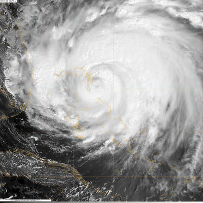
Of course, the major weather story continues to be Hurricane Irene. As of the 5PM EDT update from the National Hurricane Center, Irene is still a CAT 3 storm with maximum sustained winds of 115 mph.  Here are a couple of views of the storm from satellite:


The latest track continues to bring Irene toward North Carolina by Saturday as a powerful CAT 2 storm, then takes in right up the Mid-Atlantic toward places like Philadelphia & NYC.

Hurricane Warnings are now in effect along the coast of NC, and Hurricane Watches extend from Virginia up through the Jersey Shore.

This storm looks like it will have a major impact on NC, with serious storm surge, flooding rain, and powerful winds.  Then, what will really be interesting, is where the storm heads next.  Check out this run of the GFS forecast model, which takes this storm right over the NYC metro area.
If this storm does indeed move over or very close to NYC, it would be the first impact since 1893, as even though by that point in time it would likely be a CAT 1 hurricane, it will still bring the potential for significant wind damage and flooding.  Plus, you have to remember that wind speed increases significantly with height (since there isn't as many objects to provide friction to slow the winds)...so the tall buildings in these large cities will be susceptible to enhanced wind damage.  Certainly will be an interesting situation to watch unfold.  I hope to have more tomorrow and Saturday.

Wednesday, August 24, 2011

Cold Front/Strong Storm Chances Tonight...& Tracking Irene

Whew...it was another hot August afternoon today, but some changes are on the way, starting tonight.  Let's go to the maps and check out the big weather story around here:

This is the forecast as of 1AM Thursday, showing a fairly strong cold front coming through the region.  This front will sweep in some drier and cooler air for the rest of the week and into the weekend.  We should see temperatures fall off by around 8-10 degrees in most locations by tomorrow, and dew points should take a nice tumble from the lower 70's today, to the lower 60's tomorrow. 

As this front enters the region tonight, a few scattered storms are possible for our region.  I'm not too excited about seeing widespread storms, as the main atmospheric forcing and deeper moisture are farther to our east, but if anything does pop tonight, there could be a handful of strong storms.  Parts of S. IL & W. KY are included in a slight risk from the SPC....with damaging winds & hail the concerns.


Of course the major weather story this week is Hurricane Irene.  This storm continues to strengthen today, now up to a category 3 major hurricane, and should grow to category 4 intensity over the next 24-48 hours.  A large portion of the northeast and mid-Atlantic are under the gun to be impacted by this storm over the weekend....including the Outer Banks of NC, Washington D.C., Atlantic City, Philadelphia, New York, & Boston.  For the northeast, this could be the strongest hurricane impact since the late 1930's or 1940's.  Here's a look at Irene on satellite on Wednesday afternoon:
  
The latest forecast models continue to gradually inch the projected track of Irene to the east....which currently keeps the center of the cone of uncertainty just east of the Outer Banks of NC, and actually projects landfall around Connecticut or Rhode Island.  Again, that's not a specific forecast....just tracking the center of the model projections.  If this storm stays just offshore, that would keep the very strongest winds offshore as well, but storm surge and drenching rains will lead to big problems, and the winds will still be howling.  It's been a long time since these parts of the country have had to deal with a storm like this, so it should be interesting to see how things unfold.  Here's the latest 5-day forecast, as of Wed. afternoon: