A thin band of cloud cover running from eastern KY down into northeast AR is the only visible evidence of a cold front that has brought the leading edge of a much drier air mass into the Local 6 region. Dew points yesterday were running in the lower 70's....today, those numbers have dropped all the way into the 50's across the northern sections of the area. Nice! This drier air mass will be with us for some time to come, so it looks like we'll enjoy a nice stretch of days with at or just below average temperatures, with much lower humidity that normal.
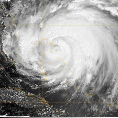
Of course, the major weather story continues to be Hurricane Irene. As of the 5PM EDT update from the National Hurricane Center, Irene is still a CAT 3 storm with maximum sustained winds of 115 mph. Here are a couple of views of the storm from satellite:
Hurricane Warnings are now in effect along the coast of NC, and Hurricane Watches extend from Virginia up through the Jersey Shore.
This storm looks like it will have a major impact on NC, with serious storm surge, flooding rain, and powerful winds. Then, what will really be interesting, is where the storm heads next. Check out this run of the GFS forecast model, which takes this storm right over the NYC metro area.
If this storm does indeed move over or very close to NYC, it would be the first impact since 1893, as even though by that point in time it would likely be a CAT 1 hurricane, it will still bring the potential for significant wind damage and flooding. Plus, you have to remember that wind speed increases significantly with height (since there isn't as many objects to provide friction to slow the winds)...so the tall buildings in these large cities will be susceptible to enhanced wind damage. Certainly will be an interesting situation to watch unfold. I hope to have more tomorrow and Saturday.


No comments:
Post a Comment