Wednesday, August 31, 2011

A Hot Start to September....Cooler Labor Day

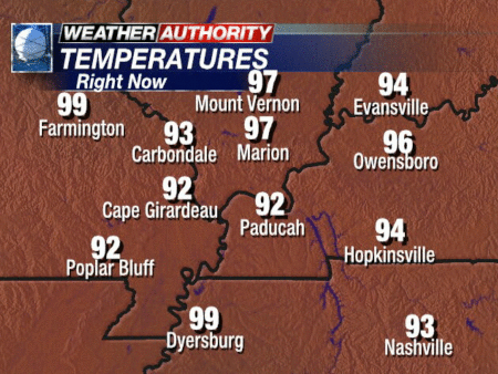
After a pleasant start to the week, we're back to some intense heat for the second half of this week.  Here is a look at some of our area's temperatures as of 4PM today:
And so the dog days of summer continue...with more heat on the way for the rest of the week. Below are shots of the surface temperature forecasts for 3PM according to the NAM forecast model...both showing upper 90's for our region, with maybe even a pocket or two of 100's in SEMO:

Thursday:
 Friday:
There is a little bit of good news, however, with these temperature forecasts.  With very little rain over the past few weeks, so much moisture has been sapped from the ground that the humidity levels will not be all that oppressive. 

As we look to the weekend, some drastic changes are on the way for area thermometers.  A pretty strong cold front looks like it will make it through the region sometime on Sunday, and that will spell big relief from this current heat.  Here's a look at the HPC map, showing the front already much of the way through the region by 7AM Sunday:
The unfortunate aspect of this frontal passage is that unless something changes, there isn't going to be much moisture to work with, and while we may have a scattered shower or two Saturday night or Sunday, we're not going to see much rain with this system....really our only chance for rain in the near future.  While a rain-free forecast is good for those Labor Day plans, we'll end up nearly 1.5" below average for the month of August. 

After the front moves through, we're in store for a refreshing change in temperatures, as numbers should end up in the upper 70's to around 80 on Monday.  And earlier today I took a glance over the 16 day GFS forecast for temperatures....Saturday could be our last 90 degree day for quite some time.

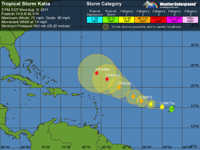
Moving from home to the tropics...still watching Katia today, as she is close to becoming a hurricane.  The 5-day forecast still continues to show this storm becoming a major hurricane over this weekend:
However, the news continues to be good for now, as the GFS ensemble models continue to show this storm curving northward before it has the chance to impact the eastern U.S.  Still way too early to make predictions with any certainty, but this storm doesn't appear that it will pose the same threat as Irene.
There is another area of disturbed tropical weather worth watching....this one is a disorganized batch of clouds and thunderstorms out in the Gulf of Mexico.  This may end up being a nice rain maker for the Gulf Coast, but the NHC is only giving it a 30% chance of becoming a named storm over the next 48 hours.

Sunday, August 28, 2011

The Week Ahead & More Atlantic Action?

As we expected, temperatures and humidity levels were down slightly for our Sunday after the passage of a weak cold front last night.  We'll get to squeeze in a couple more days with lower humidity and highs in the mid/upper 80's on Monday & Tuesday, with lows in the upper 50's to around 60.
By Wednesday, a warm front will make its way northward through the area, which will bring just a very small chance of an isolated shower or storm, and will also bring the return of the 90's and higher humidity, just in time for the beginning of September. 


Looking ahead to Labor Day Weekend, a cold front will be trying to slide in from the northwest, this will bring a chance of showers and thunderstorms to the region.  At this point in time, this looks like the best chance of rain for the next week, which isn't saying too much, considering moisture will be limited with this system.  This should bring at least a small cool down by the Labor Day holiday.

Now onto the Atlantic...just as Irene winds down, Tropical Storm Jose has joined the club.  This storm may bring some rain and wind to Bermuda, but doesn't look like it should be much of a troublemaker.

The bigger concern is a tropical wave way out in the eastern Atlantic, south of the Cape Verde Islands....currently known as "Invest 92", indicating that the National Hurricane Center is closely monitoring the system.

 As of the 8PM update tonight, the NHC was forecasting a near 100% chance of this becoming Tropical Storm Katia over the next 48 hours, and the GFS ensemble forecast models paint and interesting picture with the forecast for the possible track of this system.

As you can see by the image above....this system could be headed into the same general areas that just dealt with Irene.  Of course this system is still way too far away to even think about making any sort of specific forecast, but this certainly is attention-grabbing, and will be interesting to monitor this week.

Friday, August 26, 2011

Good Looking Weekend Here...& Irene's Impact

A very quiet weather pattern for the Local 6 area continues....I'll let the weather story graphic from the NWS Paducah do the talking.


Now...onto Hurricane Irene. Hurricane Warnings are now in effect from North Carolina all the way north into Massachusetts.  The storm has weakened a bit over the past 24 hours, now down to a CAT 2 hurricane, with max winds at 100 mph.  However, this is a huge hurricane, with hurricane force winds extending outward to 90 miles from the center, and tropical storm force winds out to a whopping 290 miles from the center.
This huge wind field means that some areas will be impacted by tropical storm force winds (39-73 mph) for anywhere from 15-22 hours!  This also allows for the water to pile up under the center of the storm, making for a large storm surge. The latest info shows storm surge potential of 6-11 feet for coastal portions of NC, and 4-8 feet from Chesapeake Bay north through Cape Cod.
And on top of all the water being pushed inland from the ocean, rainfall totals will be tremendous.  Anywhere from 6-12 inches of rain are expected with the worst of the storm, with localized totals of up to 15 inches possible.

Even though this storm has weakened a bit, it is still going to prove to be a destructive and historic hurricane for the Mid-Atlantic and Northeast.  With over 65 million people in the path of the storm, the economic impact will be rather large.  In fact, on the economic front, around 20% of the U.S. GDP comes from the area in the path of Irene, and roughly 8% of the U.S. gasoline and diesel supply comes from refineries along the east coast....so get ready to shell out even more at the pump next time you fuel up.

Thursday, August 25, 2011

Refreshing Changes & Hurricane Irene

A thin band of cloud cover running from eastern KY down into northeast AR is the only visible evidence of a cold front that has brought the leading edge of a much drier air mass into the Local 6 region.  Dew points yesterday were running in the lower 70's....today, those numbers have dropped all the way into the 50's across the northern sections of the area.  Nice!  This drier air mass will be with us for some time to come, so it looks like we'll enjoy a nice stretch of days with at or just below average temperatures, with much lower humidity that normal.  

Of course, the major weather story continues to be Hurricane Irene. As of the 5PM EDT update from the National Hurricane Center, Irene is still a CAT 3 storm with maximum sustained winds of 115 mph.  Here are a couple of views of the storm from satellite:


The latest track continues to bring Irene toward North Carolina by Saturday as a powerful CAT 2 storm, then takes in right up the Mid-Atlantic toward places like Philadelphia & NYC.

Hurricane Warnings are now in effect along the coast of NC, and Hurricane Watches extend from Virginia up through the Jersey Shore.

This storm looks like it will have a major impact on NC, with serious storm surge, flooding rain, and powerful winds.  Then, what will really be interesting, is where the storm heads next.  Check out this run of the GFS forecast model, which takes this storm right over the NYC metro area.
If this storm does indeed move over or very close to NYC, it would be the first impact since 1893, as even though by that point in time it would likely be a CAT 1 hurricane, it will still bring the potential for significant wind damage and flooding.  Plus, you have to remember that wind speed increases significantly with height (since there isn't as many objects to provide friction to slow the winds)...so the tall buildings in these large cities will be susceptible to enhanced wind damage.  Certainly will be an interesting situation to watch unfold.  I hope to have more tomorrow and Saturday.

Wednesday, August 24, 2011

Cold Front/Strong Storm Chances Tonight...& Tracking Irene

Whew...it was another hot August afternoon today, but some changes are on the way, starting tonight.  Let's go to the maps and check out the big weather story around here:

This is the forecast as of 1AM Thursday, showing a fairly strong cold front coming through the region.  This front will sweep in some drier and cooler air for the rest of the week and into the weekend.  We should see temperatures fall off by around 8-10 degrees in most locations by tomorrow, and dew points should take a nice tumble from the lower 70's today, to the lower 60's tomorrow. 

As this front enters the region tonight, a few scattered storms are possible for our region.  I'm not too excited about seeing widespread storms, as the main atmospheric forcing and deeper moisture are farther to our east, but if anything does pop tonight, there could be a handful of strong storms.  Parts of S. IL & W. KY are included in a slight risk from the SPC....with damaging winds & hail the concerns.


Of course the major weather story this week is Hurricane Irene.  This storm continues to strengthen today, now up to a category 3 major hurricane, and should grow to category 4 intensity over the next 24-48 hours.  A large portion of the northeast and mid-Atlantic are under the gun to be impacted by this storm over the weekend....including the Outer Banks of NC, Washington D.C., Atlantic City, Philadelphia, New York, & Boston.  For the northeast, this could be the strongest hurricane impact since the late 1930's or 1940's.  Here's a look at Irene on satellite on Wednesday afternoon:
  
The latest forecast models continue to gradually inch the projected track of Irene to the east....which currently keeps the center of the cone of uncertainty just east of the Outer Banks of NC, and actually projects landfall around Connecticut or Rhode Island.  Again, that's not a specific forecast....just tracking the center of the model projections.  If this storm stays just offshore, that would keep the very strongest winds offshore as well, but storm surge and drenching rains will lead to big problems, and the winds will still be howling.  It's been a long time since these parts of the country have had to deal with a storm like this, so it should be interesting to see how things unfold.  Here's the latest 5-day forecast, as of Wed. afternoon: 


Thursday, August 4, 2011

Thursday, August 4 Update

First of all, I apologize for the lack of updates over the past couple of weeks.  It's just been too hot to blog. (Not really, but I don't have any other excuses.) 

Speaking of heat, yesterday was the hottest and most oppressive day of the summer for many communities.  Check out these high temperatures and peak heat index readings from yesterday:
  • Poplar Bluff:  104/126
  • Cape Girardeau:  103/116
  • Paducah:  99/117
  • Carbondale:  98/113
Thankfully, a weak cold front slipped through most of the area, bringing a temporary break from the extreme heat for a day or two.  This front also was responsible for an isolated thunderstorm that brought damaging wind gusts to Clinton, KY and parts of Henry Co., TN.

Looking ahead, the key player in our weather picture for the next several days will continue to be this frontal boundary, which is currently stalled across the Mid-South....roughly along or just south of I-40.  The slightly cooler and drier air on the north side of the front will linger over the Local 6 area through tomorrow, along with a small chance of showers or t'storms as weak ripples of energy ride along the front.  By Friday night and Saturday, the front will begin lifting north once again, bringing a return to hotter and more humid conditions for the weekend...as well as a continued small chance of rain.  Then, by the first of next week, a little more substantial shortwave trough will dive in from the northwest, pushing the front back to the south.  This will lead to another minor break in the heat and humidity for the first half of next week, as well as more small chances for rain.  At this point it is pretty tough to nail down any specifics with regards to rain chances, as the weather systems that will lead to those chances will be fairly subtle.

As we turn the corner into the month of August, the National Weather Service offered a little perspective on how this summer's heat compares to previous years.  And while I've heard a lot of comments on this year being the hottest they remember, the period from June-July 2011 rank only as the 7th hottest on record for Paducah.  However, the kicker thus far this summer has been the humidity.  With this year being the 2nd wettest on record through July 31st for Paducah, the consistently high humidity has made things pretty unbearable.  For more details on how this summer compares, you can check out the full article by clicking here.

Finally, a quick update on Tropical Storm Emily.  This storm is still plugging away, but shear is keeping it from strengthening and posing much of a threat aside from some wind and heavy rain.  The latest update as of Thu. afternoon keeps Emily as a tropical storm as it crosses the Bahamas, then approaches the eastern coast of Florida, and then heads out into the Atlantic.  Here's the 2PM EDT update: