Good Tuesday! Not much change to tell you about for the next couple of days. A very weak front will slide through the area tonight...but don't expect much change in temperatures or humidity. Could be a stray shower tonight, but chances are in the 10% range. We'll see more near 100 heat for tomorrow and Thursday, before some slightly more promising changes enter the picture.
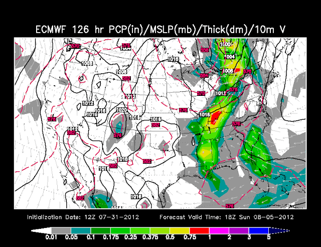
As we head toward the weekend, the big ridge to our west will begin to flatten out and a fairly promising shortwave trough will lead to some better rain chances. The ECMWF (European model) has performed pretty well this summer, and here's what today's 12Z run is showing as far as precip....
Friday:
Saturday:
Sunday:
Not to be Debbie Downer, but with our ongoing exceptional drought....I've taken a bit of a "believe it when I see it" approach to forecasting rain....but seeing the Euro cranking out precip makes me think we may have something to look forward to. The HPC 5-day rainfall forecast today is more optimistic that yesterday:
Stay tuned for more on upcoming rain chances over the next couple of days.
Finally, today we say goodbye to what has been, in the words of Laura Emerson, an "evil hot" month. We topped 90 degrees on 28 of 31 days this month, and hit at least 100 degrees a whopping 11 days! That makes a total of 57 days at or above 90 degrees this year, and a record-setting 15 days at or above 100 degrees! So will August offer any changes??? Well, according to the latest outlooks from the CPC, the answer is no. The August outlook continues to highlight above normal temperatures over a large part of the U.S.
And as you might expect, the outlook also calls for things to stay dry...
Have a good day, and here's your latest Weather Authority 7-Day Planning Forecast:


No comments:
Post a Comment